So here we are. Our current position is 38° 29.0611′ N, 076° 23.9591′ W (see a map here: http://tinyurl.com/32ralhm). The Scanfish is in the water, we’re heading south collecting data, and there is ice cream in the freezer. We ran into a few problems with the Scanfish and were not able to get data from that instrument between the Bay Bridge and the Choptank River unfortunately. However, we did get CTD data every 20 minutes, and the tech from U Delaware met the ship to help our shipboard techs diagnose the problem. Which they did, pretty quickly, putting us back in business. The RV Hugh R. Sharp crew have shirts that say “Can-Do Crew”, and they absolutely are. This is truly a wonderful ship to work with, and it feels like a home away from home being out here.
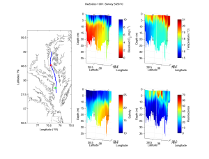
So what is all this “data” you might ask? In short we’re looking at the water properties of the main channel in the Chesapeake in order to find 2 locations to do more sampling. Our criteria are set up so the two locations provide good contrasts, and since our overall goal is to examine how low oxygen (hypoxia) affects plankton, we’re looking for one location with oxygenated bottom water, and another without it. I’ve attached a figure from our last cruise.

DeZoZoo 1001: map of Scanfish survey with station locations, and 3D plots of four variables: Temperature, Salinity, Fluorescence, and Dissolved Oxygen.
You can see the low oxygen water (in red) is most intense at the northern end of the transect – near the Bay Bridge. Our station locations from that last cruise are also on this plot, and we’ll see if those will work again this trip. However, this time of year finding hypoxia bottom water in the main channel is pretty easy, particularly between the Bay Bridge in the north and the Potomac in the South, but finding fully oxygenated deep water is trickier. If we go too far south there are bigger changes in other water properties like salinity (it goes up as we approach the mouth of the Chesapeake), so we’re hoping to find locations to provide contrast before we get south of Rapahannock Shoals. Also we want the two locations to be similar in depth, because there may be differences in the response of zooplankton to different habitat depths.
Picky, picky. I know. But these are important considerations to make a robust comparison.
OK, time for an after dinner ice cream and a cup of coffee. Then it’s back to watching the Scanfish. We’ll be out here cruising until August 25th, and I’ll be writing about it as much as time allows. Pictures too, stay tuned for them.
And if you’ve been following our progress, I can report our intrepid research assistant headed to the Gulf for 28 days has made it to the ship in Gulfport, MS and is settling in on the ship. We’ll see if we can get updates from her too.
’til next time!

